Subwatershed Population Tool

Summary
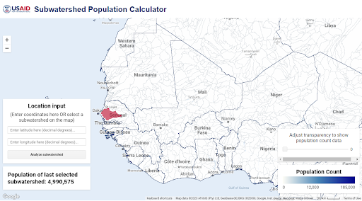
The Subwatershed Population Tool (link is external) allows users to quickly estimate the population living in a given subwatershed at the Pfafstetter 6 level. Users can simply click any location on the map or enter coordinates to get an estimate of the number of people living in a given subwatershed. This helps to estimate the people that live either in a subwatershed where measures to improve water resources management have been implemented or in a downstream subwatershed that has experienced measurably improved watershed conditions.
To see how to use the tool for reporting on USAID standard indicators, please reference the “Water Resource Productivity Indicators (HL.8.5)” section of the Global Water Strategy Indicator Handbook.