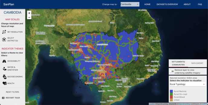
Introducing SanPlan: Use data to support programming. The Sanitation Planning Tool from USAID/WASHPaLS

The Water, Sanitation, and Hygiene Partnerships and Learning for Sustainability (WASHPaLS) team is pleased to invite you to a special presentation of the SanPlan tool, a free web-based application for employing publicly available spatial data to guide sanitation programming.
The WASHPaLS team designed this tool based on learnings from its multi-year research activities on factors that influence sanitation program success. SanPlan features overlays of multiple datasets in a way that allows users to explore and query spatial information to improve location targeting, budgeting, and program design. It also includes a customized map layer developed to classify communities and geographic areas into three typologies of accessibility -- rural remote, rural on-road, and rural mixed -- which can be used for determining the type of sanitation intervention most suitable for a particular area.
Speaker names and titles:
Opening Remarks
Jesse Shapiro | Environmental Health Team Lead, Senior WASH Advisor, and Sanitation Focal Point, USAID
Presenters/Moderators
Kara Stuart | Research & Program Manager, WASHPaLS/ The Aquaya Institute
Jessica Tribbe | Research & Program Manager, WASHPaLS/ The Aquaya Institute
With recorded demos from:
Nicole Helme | Senior Monitoring, Evaluation & Learning Specialist, Global Communities
Sokha Mok | Program Manager, WaterAid
Related Global Waters resources/assets:
- Targeting Community-Led Total Sanitation (CLTS) to Favorable Contexts: Factors Contributing to the Success of CLTS in Cambodia
- Targeting Community-Led Total Sanitation (CLTS) to Favorable Contexts: Factors Contributing to the Success of CLTS in Ghana
- Targeting Community-Led Total Sanitation (CLTS) to Favorable Contexts: Factors Contributing to the Success of CLTS in Liberia
- Targeting Community-Led Total Sanitation (CLTS) to Favorable Contexts: Factors Contributing to the Success of CLTS in Zambia
- Sustaining Latrine Coverage and Use: A Study of the Cambodia Rural Sanitation and Hygiene Improvement Program (CRSHIP I)
- Sustaining Latrine Coverage and Use: A Study of Community-Led Total Sanitation Programs in Northern Ghana

