Harnessing the Power of the Web for Agricultural and Climate Data Analyses

The Story
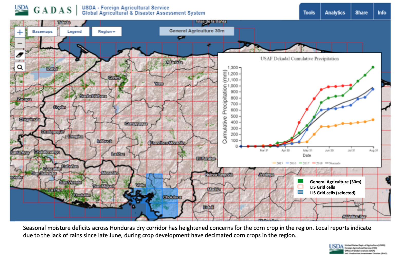
Satellite imagery and remote sensing data assist the U.S. Department of Agriculture (USDA) in formulating monthly estimates of global production of 17 agricultural commodities. Using a wide range of data layers from several sources, the USDA Foreign Agricultural Service (USDA/FAS) developed the Global Agriculture and Disaster Assessment System (GADAS) platform for its analysts and other users to rapidly visualize the current conditions of crops around the world, and compare current conditions to historic trends for a particular crop or place.
Precipitation, irrigation infrastructure, and other water-related data are among the multitude of data streams that are integrated into GADAS. In addition, USDA/FAS has partnered with the Pacific Disaster Center in Hawaii to incorporate real-time data streams to GADAS for worldwide monitoring, tracking, and pre- and post-disaster assessments of hurricanes, typhoons, tsunamis, floods, droughts and other disasters that impact agriculture. In June 2018, FAS launched a public web portal to GADAS, thereby making this tool globally accessible for site-specific analyses of water, major crops, and overall food security.
Meanwhile, in partnership with USAID, USDA/FAS began training a cohort of five analysts at the Honduras Foundation for Agricultural Research to utilize GADAS and other tools to improve their estimates of Honduran crop production. As USDA/FAS's technical assistance to Honduras proceeds, it is anticipated that the Honduran analysts will explore additional GADAS functions, like helping to monitor agricultural water resources and irrigation infrastructure in Honduras.
Also in partnership with USAID, USDA/FAS continued its technical assistance to Pakistan for agricultural development, including improved management of soil and water resources. In October 2018, a team of USDA experts conducted soil and water conservation workshops with Pakistan's National Agricultural Research Center, the International Center for Agricultural Research in Dry Areas, and other stakeholders. The workshops focused on the Gomal Zam Dam area as a local case study for the participants to examine Pakistan's current capacities and options for improving watershed management and irrigation water delivery.
As USDA/FAS's technical assistance collaborations in Honduras, Pakistan, and other countries proceed, GADAS will help USDA/FAS and its partners quickly provide "real-time" visual information to relevant land users, water managers, researchers, policymakers and others who are involved in developing practical solutions to complex agricultural challenges, like water access, quality, and timing for sustainable crop production.
Find More
Strategic Objective(S)
 Water Resources Management
 Governance and Financing


Highlight